Museums are usually in hands of enthusiasts who repair forts and they are also guides in those forts. Entrance fees to forts are low, about 30-60 Kè (up to 3$) or voluntary. I would recomend to visit all fortresses - Bouda, Hanièka (Hanicka) and Dobrošov (Dobrosov), because they heve large underground network and more forts on the surface in quite small area. And also some well preserved blockhouses eg. N-82 Brezinka, K-5 U potoka and museum in Darkovicky. Museums listed below are only examples wich you can visit. There are many other museums which are not listed there.
|
|
|---|
 |
|---|
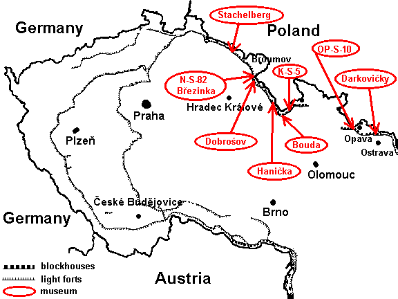
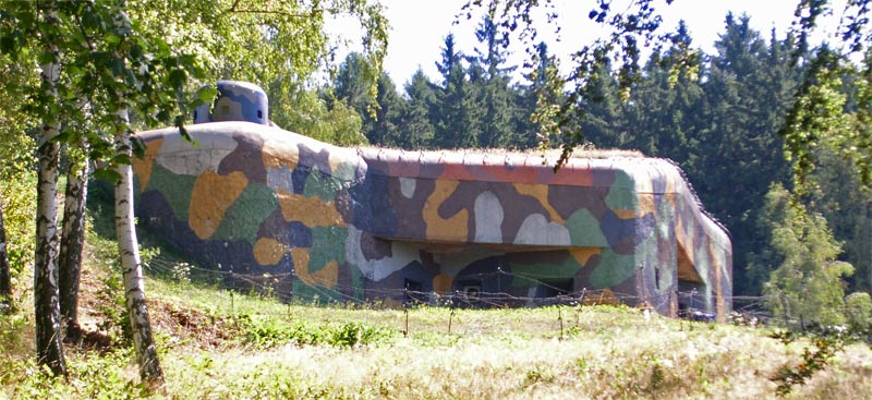
| Infantry blockhouse MO-19 "Alej" |
This museum consits of four forts - three blockhouses for infantry (MO-18 "Obora", MO-19 "Alej" and MO-20 "Orel" )
and one light fort. MO-19 is one of the best preserved forts in the Czech Republic. Now it is equipped with
original weapons and other original
equipment. It also has bells and a cupola.
Situation: Darkovièky (Darkovicky) near Hluèín (Hlucin)
GPS: 49°55'31.299"N, 18°13'16.866"E
Opening times:
One reconstructed blockhouse for infantry with some historical weapons around (T-34, OT-810, 152mm Soviet howitzer).
Situation: Malé Hoštice (Male Hostice) -the eastern direction from Opava
GPS: 49°56'14.470"N, 17°57'18.473"E
Address: Rudolf Jatzek, Vanèurova (Vancurova) 380, Velké Hoštice
(Velke Hostice) 747 31
One reconstructed blockhouse for infantry.
Situation: map
GPS: 50°6'36.22"N, 16°48'26.421"E
Opening times:
 |
|---|
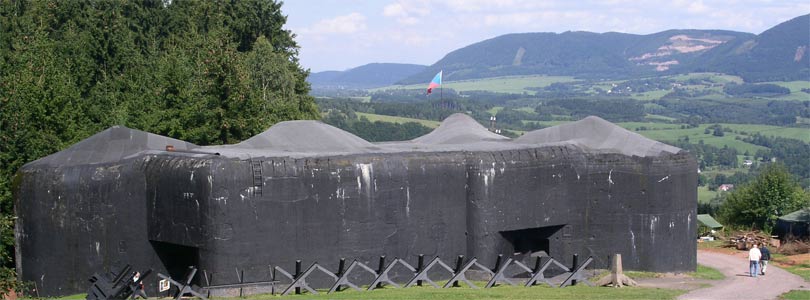
| blockhouse of entry K-22a "Krok" |
 |
|---|
| fort for artillery turret K-22 "Horymír" ("Horymir") |
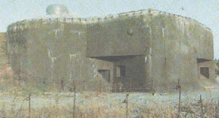
One of the largest museum beside Hanièka (Hanicka) and Dobrošov (Dobrosov)
in the Czech Republic. It consists of five forts connected by underground corridors. Visit starts
in the blockhouse of entry (the only one in the Czech Republic) named K-22A "Krok" then you visit
large undeground barracks, weapons stores and many other underground facilities. Back
on the surface you can visit the remaining forts K-21 "Kazi", K-23 "Teta", K-24 "Libuše" ("Libuse")
and fort for an artillery turret K-22 "Horymír" ("Horymir"). The visit of the undeground takes
about one hour. Temperature in the underground is about 10 C (50 F), so take some warm clothing.
Situation: About 40 min. from the parking place in Suchý vrch (Suchy vrch), following
the red turictic route to Mladkov. Suchy vrch is accesable from Èervená Voda (Cervena Voda)
near Králíky (Kraliky). MAP
GPS: 50°4'9.6236"N, 16°40'37.164"E
Opening times:
Nowdays the largest museum in the Czech Republic consists of six forts - one blockhouse of entry (R-79a "U silnice"), three infantry forts (R-76 "Lom", R-77 "Pozorovatelna", R-80 "U potucku"), one artillery fort (R-79 "Na mytine") and one fort for an artillery turret (R-78 "Na pasece"). This fortress has the most interesting history. In years 1969-1975 it was an official musem, but in 1975 the Department of interior became the owner of the fortress, so it was closed for visitors. Hanicka became a large building site, because it was planned to rebuild the old fortress to a bunker resistant enough to survive a nuclear attack for important people from the Communist party. Rebuilding started in 1981 and was stopped few years after the fall of the Communist party. Hanicka became a museum (for the second time) in 1995. Because of the recostruction of the whole fortress one can see new generators, gas protection system and water tanks in the interior, but all of them are new. One can't see much of the old equipment such in MO-19 "Alej", but everything is in perfect condition. Forts on the surface changed only slightly, some of them are entirely covered by earth or some structures are added to walls, but Hanicka is also the only place where one can see quite a lot of bells and cupolas, in fact fortress Hanicka, MO-19 and group of forts "Bouda" are the only places where one can see them except for a few exceptions, but those are not open to the public. The visit of the underground takes about one hour. Don't forget some warm clothing.
Situation: near Rokytnice v Orlických horách (Orlickych harach)-not far from
Žamberk (Zamberk). Acces by car following the route from Rokytnice v O. h. to Bartošovice
(Bartosovice) v O. h..There is a parking place in village Hanicka. Then follow signs
to the fortress (1.5 km).
GPS: 50°11'47.274"N, 16°30'34.811"E
Opening times:
Building of that fortress wasn't finished before the Naci ocupied Czechoslovakia, so only three (N-72 "Mustek" -infantry , N-73 "Jerab"-infantry , N-75 "Zeleny" -artillery) of the seven planned forts were built. Nevertheless I recommed to visit this fortress. There you can see one of the two accessable artillery forts for three 10cm howitzers. The visit of the underground takes about one hour like in other fortresses. There is also an display of models of forts, military vehicles etc. in the building behind the forts, a large display is also inside this fortress. There is also a large tunnel network like in the fortress Bouda and Hanicka.
Situation: Village Dobrošov (Dobrosov) -acces by car from Náchod (Nachod)
take direction to Nový Hrádek (Novy Hradek). There is a large parking place by the road near
the fortress.
GPS: 50°24'12.050"N, 16°12'14.450"E
Opening times:
 |
|---|
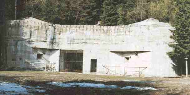
| Infantry blockhouse N-82 "Bøezinka" ("Brezinka") |
Another well reconstructed infantry fort with historical weapons, a copy of a bell and many unique
facilities like a ventilation and gas protection system and many other. It has also the historical
marking. Once a year there is a big parade connected with the so called "battle of Brezinka".
It is a battle which never happened in reality (Czechoslovakian forts didn't fight with any
enemy except at the end of the WWII, when the remaining German units used the forts around
Ostrava against the approaching Red army), but it seems like the reality - armored German vehicles,
motorcycles and German soldiers are attacking the fort...
Situation: Peak over Náchod (Nachod)- access from hotel "Bonato" (with
a parking place) in spas Bìloves (Beloves) in Nachod following the green touristic route up to
the peak (about 800 m) or following the green touristic route from Dobrošov (Dobrosov) down
to Nachod - you can also visit many unpreserved forts by the route down the peak (2-3 km).
GPS: 50°24'55.478"N, 16°11'53.071"E
Opening times:
 |
|---|
| Infantry blockhouse T-73 |
Stachelberg was planned to be the largest fortress in Czechoslovakia - four infantry
forts, two artillery forts, two forts for mortar turret, two forts for artillery turrets and one
enrtance fort, but only one infantry fort, T-73, was completed. A group of enthusiasts
repaired this fort, one light fort and two heavy forts near the fortress, but they aren't a
part of Stachelberg. There is an exposition of historical photos of forts in T-73.
The visit takes about 60 min. Visitors can also visit a part of the underground.
Situation: Peak over village Babí (Babi). Acces by car followig route from
Trutnov to Žacléø (Zacler). Turn right to the local road (about 1km after end of village Babi) and
follow the signs.
GPS: 50°37'49.982"N, 15°54'42.810"E
Opening times: